From glacier-fed lakes to dramatic alpine peaks, Switzerland is a dream destination for hiking enthusiasts. Whether you’re a casual walker or a seasoned mountaineer, the Swiss Alps offer an unforgettable blend of beauty, challenge, and awe at every turn. This post will give you an insight into the different types of trails available, and what to potentially expect.
The SwissTopo App is extremely helpful when planning and preparing for any hikes within Switzerland, and it is recommended that anyone planning to hike use the app.
For more Swiss holiday adventures, check out a scenic train journey through Switzerland, or exploring Lucerne.
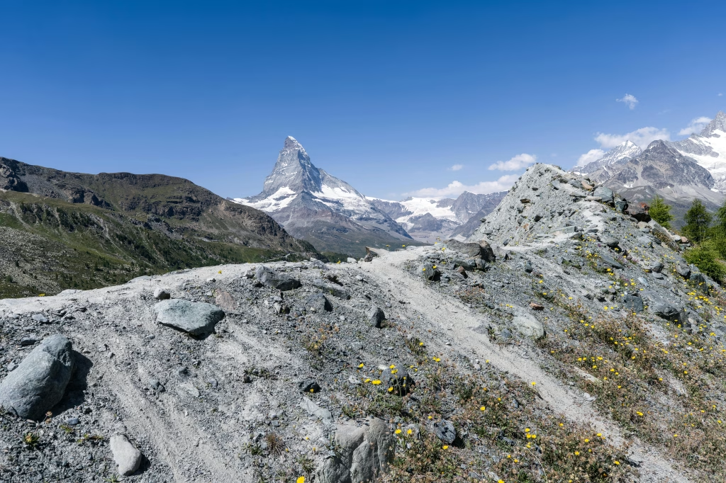
1. Matterhorn Glacier Trail
Location: Zermatt, Valais
Difficulty: Moderate to Challenging
Length: 6.5 km (approx. 2–3 hours)
Elevation Gain: ~150 m
One of the most scenic hikes in Switzerland, the Matterhorn Glacier Trail offers an unforgettable alpine experience. Starting at Trockener Steg, this high-altitude trail guides you through dramatic glacial landscapes, past small alpine lakes, and across the moraine left behind by the Theodul Glacier. Information panels along the route provide insights into the geology and glaciology of the area. The highlight, of course, is the up-close view of the iconic Matterhorn towering above the trail. This is a must-do for photographers and nature lovers.
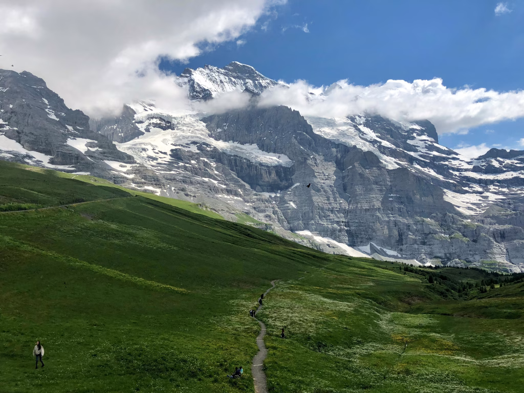
2. The Eiger Trail
Location: Grindelwald, Bernese Oberland
Difficulty: Moderate
Length: 6 km (approx. 2–2.5 hours)
Elevation Gain: ~250 m (mostly downhill from Eigergletscher to Alpiglen)
Tracing the base of the world-famous Eiger North Face, this hike offers a thrilling experience with less physical effort. The Eiger Trail begins at Eigergletscher station and descends toward Alpiglen, revealing jaw-dropping vistas of the Grindelwald Valley, waterfalls, and alpine pastures. It’s a popular route for families and day hikers and is well-marked and maintained. Along the way, interpretive signs tell stories of climbing attempts on the Eiger’s treacherous wall. The descent is gentle, making it ideal for casual hikers looking to soak in the alpine atmosphere.
3. Piz Bernina Summit Route
Location: Engadin Valley, Graubünden
Difficulty: Very Challenging (technical mountaineering route)
Length: ~20 km (multi-day climb with glacier crossings)
Elevation Gain: ~2,200 m
Switzerland’s only 4,000-meter peak in the Eastern Alps, Piz Bernina offers a true mountaineering adventure. Typically approached via the Tschierva or Boval huts, the route demands excellent fitness, experience with crampons and rope work, and glacier navigation skills. The views from the summit are truly spectacular, offering sweeping vistas over the Morteratsch Glacier and the nearby peaks of the Bernina Range. This is a bucket-list climb for experienced alpinists.
4. Lauterbrunnen Valley to Schilthorn
Location: Lauterbrunnen, Bernese Oberland
Difficulty: Moderate
Length: ~13 km (approx. 4–5 hours)
Elevation Gain: ~1,200 m
Begin in the stunning Lauterbrunnen Valley, framed by sheer cliffs and waterfalls, and ascend through charming villages like Gimmelwald and Mürren before reaching the Schilthorn summit. Along the way, you’ll be rewarded with views of the 72 waterfalls cascading down the valley walls. The final leg to Schilthorn can be strenuous, but the panoramic 360° views of the Eiger, Mönch, and Jungfrau are worth the effort. A revolving restaurant at the summit adds a fun, cinematic touch (the James Bond film On Her Majesty’s Secret Service was filmed here).

5. The Via Alpina (Swiss Stage)
Location: Spanning Eastern to Western Switzerland
Difficulty: Challenging (long-distance, multi-day)
Length: ~390 km total (Segment A1–A20 in Switzerland)
Elevation Gain: Thousands of meters across 20 stages
This grand traverse of Switzerland takes hikers across the heart of the Alps from Vaduz (Liechtenstein) to Lake Geneva. Each of the 20 stages averages 15–20 km per day and crosses scenic valleys, mountain passes, and traditional Swiss villages. Popular sections include the Gasterntal Valley, Grindelwald to Lauterbrunnen, and Kandersteg to Adelboden. It’s well-marked and supported by local accommodations, making it accessible to those looking for a long-distance hiking experience without camping.
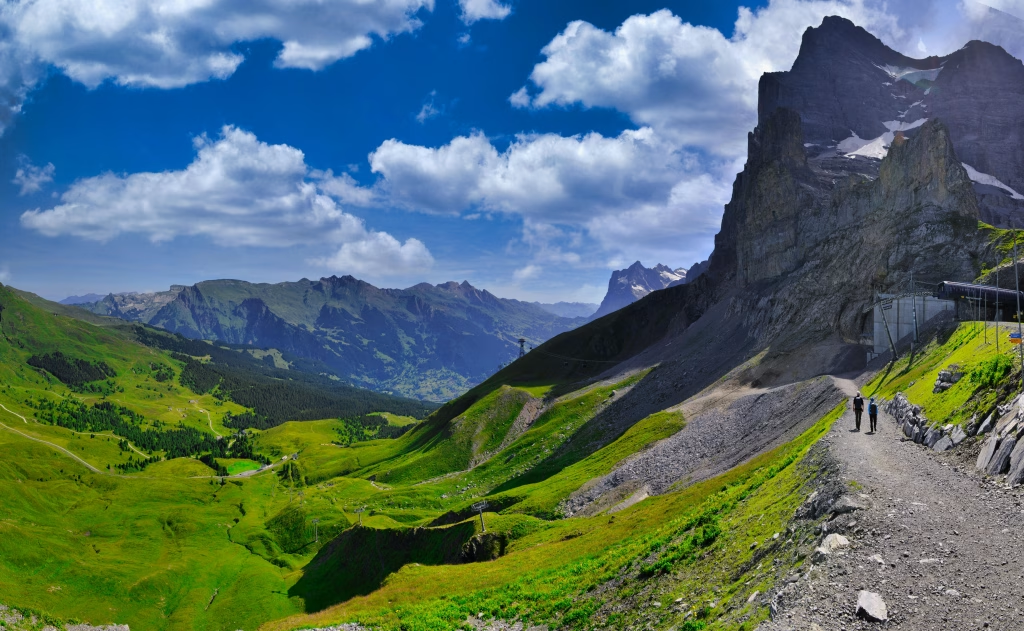
6. Faulhorn to First
Location: Grindelwald, Bernese Oberland
Difficulty: Moderate
Length: 6 km (approx. 2 hours)
Elevation Gain: Mostly downhill (if starting at Faulhorn)
This popular trail is part of the larger Schynige Platte to First route, but can be shortened by starting at Faulhorn (reachable by hiking or cable car). The route offers postcard-worthy views of the Bernese Alps, especially of the Eiger, Mönch, and Jungfrau. You’ll pass by the crystal-clear Bachalpsee lake — a favorite photo spot. The trail is wide and relatively easy to follow, making it suitable for families and beginner hikers.
7. Mont Collon Traverse
Location: Swiss–Italian Border (Valais / Aosta Valley)
Difficulty: Challenging (glacier and high-altitude trekking)
Length: ~18 km (multi-day)
Elevation Gain: ~1,500 m
The Mont Collon Traverse is a lesser-known but equally stunning alpine hike that involves glacier crossings, high passes, and dramatic scenery. Often included in advanced routes like the Haute Route, this trek is only recommended for hikers with mountaineering experience or with a guide. The trail links mountain huts and offers breathtaking views of the Arolla Glacier and surrounding peaks. Overnight stays in mountain huts make this a true alpine immersion.
8. Gornergrat Ridge Trail
Location: Zermatt, Valais
Difficulty: Moderate
Length: ~8 km (approx. 3 hours)
Elevation Gain: ~300–800 m depending on start point
Take the scenic cogwheel train to Gornergrat and explore the ridge trails overlooking the Gorner Glacier and the Matterhorn. Unlike more technical hikes, these well-maintained paths allow for leisurely exploration at high altitude without the need for special gear. You can start at the summit and descend, or vice versa, making this flexible for various fitness levels. Along the way, alpine lakes and flower-strewn meadows offer perfect picnic spots.

9. Säntis Peak Trail
Location: Appenzell, Eastern Switzerland
Difficulty: Moderate to Challenging
Length: ~9 km round-trip (approx. 4–5 hours)
Elevation Gain: ~1,000 m
Säntis (2,502 m) is the highest peak in the Alpstein range, offering dramatic views over northeastern Switzerland and even into Austria, Germany, and France on a clear day. The hike from Schwägalp is steep and rocky, with some exposed sections requiring surefootedness. There’s a cable car option for those who want to ascend or descend more comfortably. At the summit, you’ll find a weather station, panoramic decks, and a restaurant.
10. Jungfrau Region Trails
Location: Grindelwald, Lauterbrunnen, Wengen
Difficulty: Easy to Challenging
Length: 3 km to 15+ km depending on trail
Elevation Gain: Varies widely
The Jungfrau region is a hiking paradise with hundreds of kilometers of trails to suit every level. Notable routes include:
- Männlichen to Kleine Scheidegg: ~4.5 km, mostly flat with jaw-dropping panoramic views
- Lauterbrunnen–Wengen loop: ~8 km, moderate trail through alpine forests and meadows
- Northface Trail (Mürren): ~7 km, mid-level hike with views of the Eiger, Mönch, and Jungfrau
The region is supported by excellent cable car and train infrastructure, allowing hikers to mix and match routes or bail out early if needed. Consider purchasing a Jungfrau Travel Pass for unlimited transport access during your hiking trip.